 Thanks for connecting!


Pragya Sharma
39 min read
July 23, 2024


Table of Contents

What is Navisworks?

Developed by Autodesk, Navisworks is a 3D model review software that helps construction and design professionals to examine and coordinate building and infrastructure projects. It serves as a platform to analyse, evaluate, and integrate 3D models alongside data from various disciplines involved during a construction project. This allows Naviswork to function as a central platform that facilitates collaboration between various software engaged in the project.
7 Benefits of Navisworks for Design and Construction Project

Navisworks is a cutting-edge software that brings practicality to the table alongside design. It brings perspective to the project, allowing professionals to visualise what’s truly possible. Using Navisworks, people can identify bottlenecks and work towards them. Look at the advantages of Navisworks below:
1. Enhanced Collaboration
Navisworks can integrate data from various design tools and formats. Since architects and civil engineers work with a range of software for modelling, analysis, and project documentation, using Navisworks enables them to seamlessly incorporate all that data in its interface. This integration fosters coordination among project stakeholders, thus reducing misunderstandings and ensuring everyone is on the same page. Learn Navisworks, as an civil engineers in USA with our online training programs tailored to upskill civil engineers.
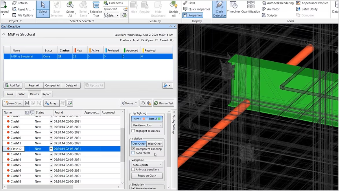
2. Clash Detection and Resolution
By using Navisworks, professionals can identify and highlight clashes between different building elements, such as structural components, mechanical systems, and electrical conduits. The detection of conflicts helps architects and civil engineers to address them before construction begins; saving time, reducing costs, and minimising rework.
3. Comprehensive Project Visualisation
Navisworks provides robust design visualisation capabilities, allowing architects and engineers to create detailed project 3D models. These models offer an immersive design view, helping stakeholders understand the project's scope, aesthetics, and functionality. High-quality visualisations also aid in client presentations, making it easier to communicate design intent and secure approvals.

4. Time-saving 4D Simulation
Navisworks supports 4D simulations, which incorporate time as a fourth dimension alongside the 3D model. This feature empowers professionals to create construction schedules and visualise the sequence of activities over time. By simulating the construction process, project teams can identify potential scheduling conflicts, optimise workflows, and ensure timely project completion.
5. Accurate Project Estimation
A key ability of Navisworks is generating accurate Bill of Quantities (BOQs) and costing. This helps designers and engineers to develop precise budgets and avoid cost overruns. It facilitates value engineering, where different design options can be evaluated based on their cost implications.
6. Improved Risk Management
Navisworks aids in identifying and mitigating project risks through its comprehensive analysis features. By visualising the entire project and understanding the interdependencies of different elements, architects and engineers can foresee potential risks and develop strategies to address them.
7. Streamlined Communication
Adopting Navisworks offers a range of tools for generating reports, creating markups, and sharing project information with stakeholders. These features ensure that everyone involved in the project has access to the latest data and can provide feedback in a structured manner. Streamlined communication reduces the likelihood of errors and ensures that project goals are met efficiently.
Also Check Out: Understanding Autodesk Navisworks: A Comprehensive Guide
3 Naviswork Versions Every Architect and Engineer Must Know
Autodesk offers 3 distinct Navisworks types in the form of versions (structured as levels) each created to meet different needs within the design and construction industry. The functionality of these formats varies on various levels, allowing professionals to download Navisworks type that is the most suited option for their project requirements and workflow needs. The three different versions offered are:
- Beginner level: Navisworks Freedom
- Mid-level: Navisworks Simulate
- High level: Navisworks Manage
1. Navisworks Freedom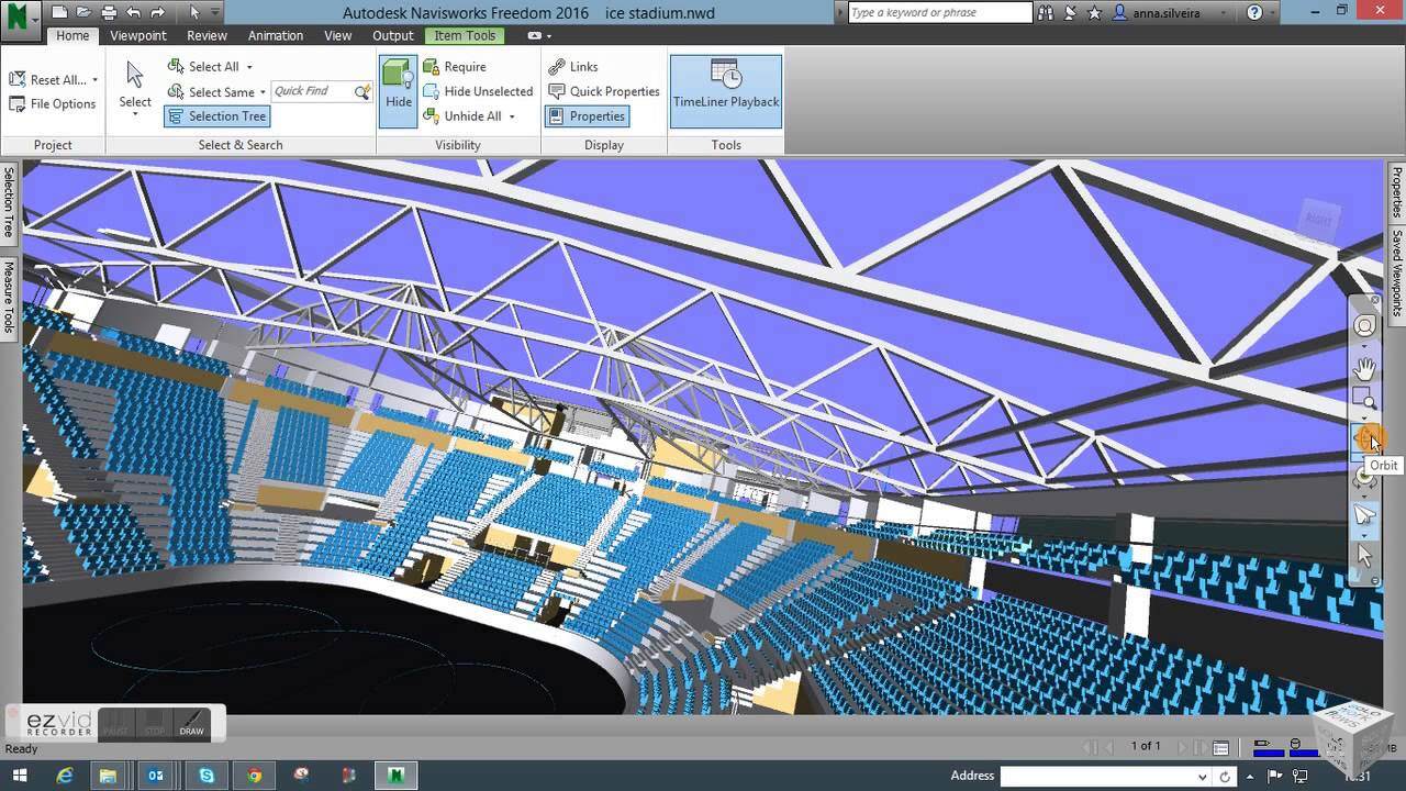
Navisworks Freedom is the most easy-to-use fundamental version of the software and is often referred to as the Navisworks viewer. It is an entry-level offering that serves as a “viewer” for Navisworks files that support .NWD and .DWF formats. Though it lacks the advanced features of the paid versions, this free version still offers valuable functionality for the stakeholders to only navigate and review the model without the requirement to modify it. This version is specially useful for clients and contractors for navigating 3D models, performing basic measurements and adding markups.
With limited tools, professionals can navigate models, review object properties, display and edit existing viewpoints, playback project simulation, access the model hierarchy, and take measurements.
Pros
- Cost-free version
- Easy to use for basic model viewing
- Facilitates project understanding for non-technical team members
- Provides a wide distribution of models to support collaboration
Cons
- Limited functionality compared to paid versions
- No editing or advanced reviewing capabilities
- Cannot create or modify projects
- Lacks clash detection and scheduling features
2. Navisworks Simulate

Navisworks Simulate is a level up from Navisworks Freedom as it offers more functions by allowing the stakeholders to do more than just navigate and review the model. It is a paid Navisworks version but provides value for money. It offers a set of sophisticated features such as native clash detection, 4D simulation and scheduling, photorealistic rendering, quantification tools for takeoffs, and a review toolkit for comments and markups.
Pros
- Powerful visualisation capabilities
- Enables scheduling for better project planning
- Improved collaboration tools over Freedom
- Suitable for mid-sized projects and teams
Cons
- Lacks full clash detection capabilities
- Complex for users who need only basic viewing
- Lack of advanced coordination features

3. Navisworks Manage
Navisworks Manage is the highest one in the hierarchy of Navisworks types, offering a comprehensive set of tools. Users can explore the software's full potential by gaining premium access. This Navisworks version offers advanced BIM clash detection and interference checking, clash and issue management tools, TimeLiner for 4D planning and simulation, animator for creating complex animations, comprehensive review and markup tools, and advanced quantification capabilities.
Pros
- Full suite of coordination and assessment tools
- Powerful conflict detection for figuring out and resolving conflicts
- Comprehensive undertaking assessment capabilities
- Ideal for massive, complex projects with more than one disciplines
Cons
- Highest cost compared to other versions
- Steeper getting-to-know curve because of the complicated feature set
- For smaller projects or teams, this may be overkill
- Requires extra effective hardware for the most desirable overall performance
Comparison Between Navisworks Freedom Vs. Simulate Vs. Manage
Here’s a table that provides a quick overview of features and capabilities across all three Navisworks versions.
|
Feature/Capability |
Freedom |
Simulate |
Manage |
|---|---|---|---|
|
Navisworks file viewer |
✔ |
✔ |
✔ |
|
Basic navigation |
✔ |
✔ |
✔ |
|
Measurement tools |
✔ |
✔ |
✔ |
|
Basic markup |
✔ |
✔ |
✔ |
|
Object properties viewing |
✔ |
✔ |
✔ |
|
4D simulation and scheduling |
X |
✔ |
✔ |
|
Advanced animation creation |
X |
✔ |
✔ |
|
Photorealistic rendering |
X |
✔ |
✔ |
|
Clash detection viewing |
X |
✔ |
✔ |
|
Clash detection creation |
X |
X |
✔ |
|
Quantification tools |
X |
✔ |
✔ |
|
Advanced review toolkit |
X |
✔ |
✔ |
|
Multi-format file support |
X |
✔ |
✔ |
|
Interference checking |
X |
X |
✔ |
|
Clash and issue management |
X |
X |
✔ |
|
TimeLine for 4D planning |
X |
X |
✔ |
|
Scripter for task automation |
X |
X |
✔ |
|
Advanced qualification |
X |
X |
✔ |
|
Cost |
Free |
₹60,180 for a 1-year subscription |
₹1,49,860 for a 1-year subscription |
|
Type of projects |
Suitable for basic viewing |
Mid-sized projects |
Large and complex projects |
How to Choose the Right Navisworks Type for Your Project?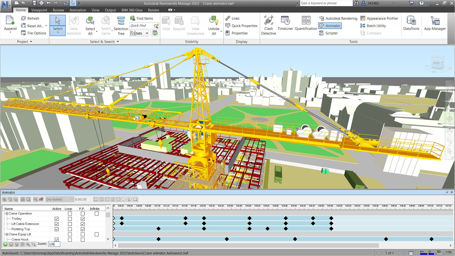
AEC (Architecture, Engineering, and Construction) professionals can select the Navisworks version that aligns best with their project scale, team capabilities, and budget constraints. The right choice can significantly enhance project coordination, reduce errors, and improve overall project outcomes.
Here are some factors to consider when choosing the appropriate versions:
- Project size and complexity
- Team collaboration needs
- Budget constraints
- Required features
- Integration with existing software ecosystem
Also Check out: Best Online Navisworks Courses for Architects and Civil Engineers
6 Components of Navisworks Versions You Must Know
Navisworks provides an array of tools and features to enhance the quality of AEC projects. Let’s explore these components individually in detail.
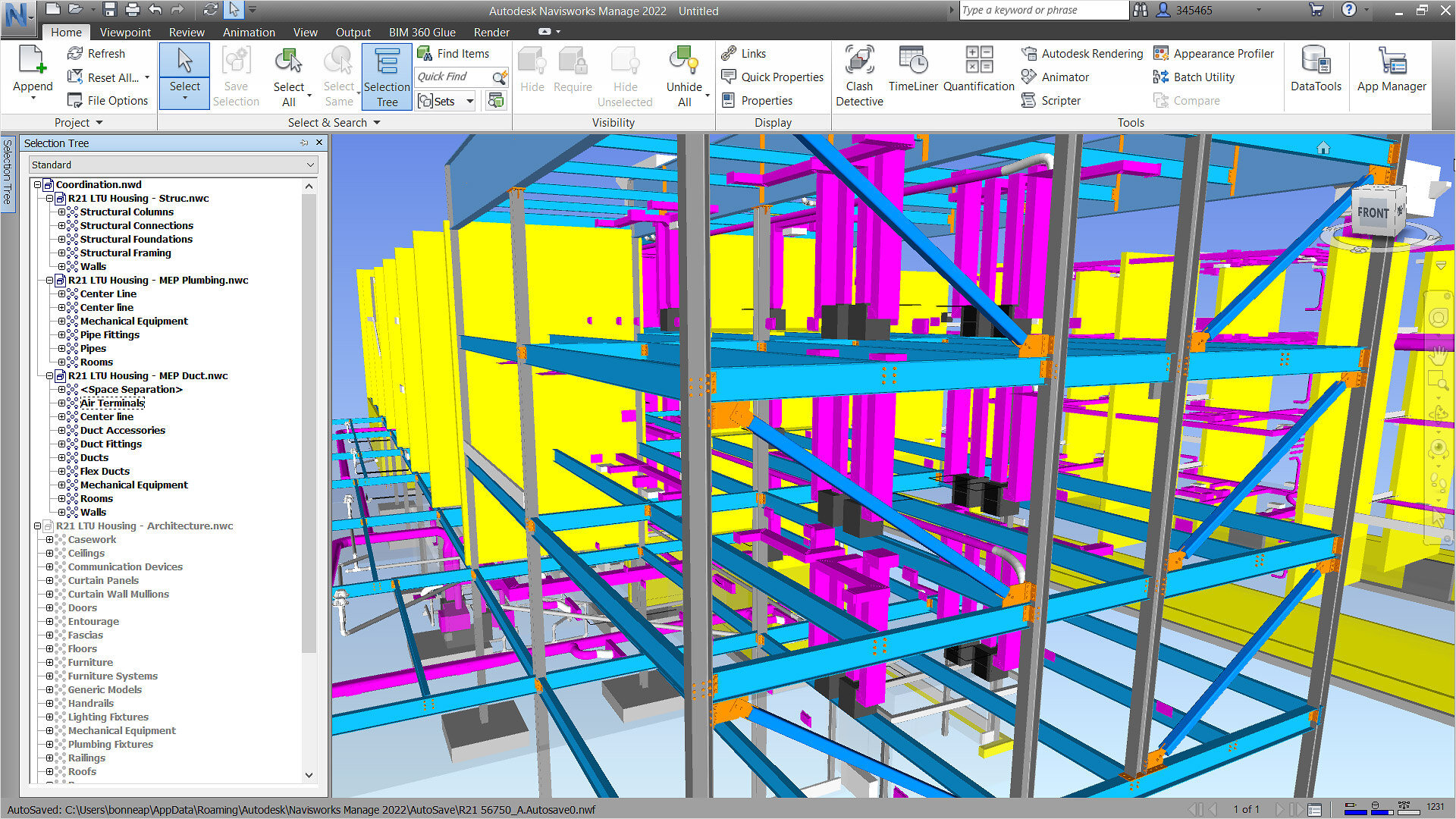
1. Model Aggregation
Model Aggregation enables users to combine 3D models from various software into a single, cohesive model. This is particularly useful in large projects where different teams might be using different tools and formats. Professionals can easily identify and resolve conflicts and clashes between different disciplines, such as architecture, structural, and MEP (Mechanical, Electrical, and Plumbing).
2. Navisworks Clash Detection
Users can run various BIM clash detection tests to identify where elements might interfere with each other. Detailed reports can be generated, highlighting the location and nature of each clash. Furthermore, clashes can be grouped and managed collectively, making it easier to track and resolve issues.
3. Timeliner
The Timeliner tool integrates 4D simulation capabilities into Navisworks, allowing users to create construction schedules linked to their 3D models. Engineers can import project schedules from software like Microsoft Project or Primavera and visualise the construction sequence over time to identify potential delays and optimise workflows.
4. Quantification
The Quantification tools help in creating accurate material estimates directly from the 3D model. With Navisworks, professionals can measure lengths, areas, and volumes directly within the model using takeoff tools. Predefined catalogs are available to standardise and streamline the quantification process.
5. Rendering and Animation
People can choose from a variety of rendering styles to highlight different model aspects #and create walkthroughs to better communicate their design intent. The software also allows users to apply realistic lighting and material properties to enhance the visual model quality.
6. Collaboration Tools
Navisworks aids communication by allowing comments and markups directly to the model. Sectioning tools allow users to create sections and slices of the model to focus on specific areas and details. Shared views can be generated to share with stakeholders who can review and provide feedback without needing the full software.
Which File Formats are Supported By Navisworks? 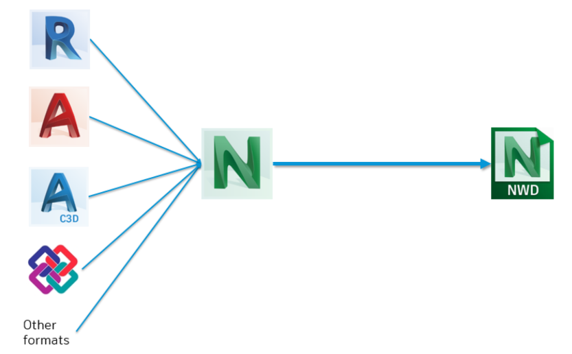
Navisworks file types supports a wide range of file formats which makes it a versatile tool for integrating models from a myriad of software. Some key file formats supported by Navisworks include:
- AutoCAD (DWG, DXF): Widely used in architectural and engineering drawings.
- Revit (RVT): Common in Building Information Modeling (BIM) workflows.
- IFC (Industry Foundation Classes): An open standard for BIM data exchange.
- MicroStation (DGN): Used in infrastructure projects.
- 3DS Max (3DS, FBX): Used for 3D modeling and rendering.
- SketchUp (SKP): Popular for architectural and interior design.
- SolidWorks (SLDPRT, SLDASM): Used in mechanical design and engineering.
- Inventor (IPT, IAM): Common in product design and manufacturing.
- Navisworks (NWD, NWC, NWF): Native file formats for Navisworks.
- Point Cloud Data (PTS, PCG, RCS, RCP): Used for representing 3D scanned data.
- Bentley (DGN): Used in infrastructure projects.
Additionally, the software also supports Navisworks plug-ins that enhance the operability of the Computational Design process.
How Can Navisworks Enhance BIM Processes?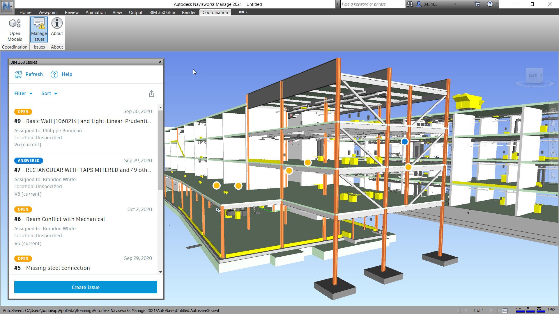
The relationship between BIM & Navisworks is highly interdependent. The latter is an essential tool that enhances the efficiency of BIM processes. The software’s ability to compile multiple model types into a single project ecosystem summarises the BIM concept of a “single source of truth”. The advanced features like clash detection, 4D scheduling, and sophisticated visualisation tools enhance the BIM workflows. Embedded in the BIM model, these features assist in resolving potential conflicts and issues early. This optimises construction sequences and improves the overall project understanding among stakeholders.
As the design and construction industry continues to embrace digital transformation, tools like Navisworks have become a crucial part. These tools facilitate smoother project delivery and better outcomes. For professionals involved in BIM projects, mastering Navisworks is essential to enhance their ability to contribute to efficiency, collaboration and delivery of successful project outcomes. Further, it can help professionals elevate their career to the next level and bring better paying opportunities.
In Conclusion
With technological advancement, we can anticipate future iterations like AI-powered clash detection and analysis, cloud-based coordination, integration of generative design, AR & VR within the Naviswork user interface. As sustainability is critically increasing, Navisworks may even integrate tools for environmental impact analysis and energy efficiency optimisation. By embracing such future advancements, Navisworks will be well-positioned to lead the tech-driven design and construction landscape. This will enable Navisworks to solidify its position as the go-to platform for collaborative BIM workflows.
Ready to take your project coordination to the next level with Navisworks? Here's how you can get started:
Novatr offers two BIM Professional Courses - one for architects and another for civil engineers, respectively that is tailored to the specific needs of the profession. The course curriculum largely focuses on BIM software, tools, and processes with a key focus on Navisworks. Participants get the opportunity to learn other BIM software such as Revit, ArchiCAD, and BIM 360; which helps them upskill in various job roles. Taught by AEC industry experts, the courses provide learners with triple certificates and placement assistance to unlock the potential of their career growth.
Explore the courses today!
BIM Professional Course for Architects
BIM Professional Course for Civil Engineers
Visit our Resources Page for more knowledge on industry concepts and trends.

.png)


.jpg)